What is Digital Agriculture?
Digital agriculture is an emerging field that applies digital technologies and data analytics to optimize and enhance various aspects of agricultural production. It involves using sensors, drones, GPS, and other digital tools to collect, process, and analyze data related to crops, soil, weather, and other factors that impact agricultural productivity.
One of the primary goals of digital agriculture is to increase efficiency and reduce waste by making informed decisions based on real-time data. For example, sensors can monitor soil moisture levels and optimize irrigation schedules. In contrast, drones can survey crops and identify areas needing pest control or fertilization.
Another critical aspect of digital agriculture is precision farming, which involves using GPS and other technologies to precisely control and monitor various inputs, such as fertilizers, herbicides, and irrigation, at the plant or zone level. This allows farmers to target specific field areas and optimize the use of these inputs, reducing costs and environmental impact.
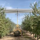
Remote sensing is a crucial component of digital agriculture, as it provides data to inform decision-making and optimize various aspects of agricultural production. Remote sensing refers to using sensors and other technologies to collect data from a distance, typically from an aircraft or satellites. In agriculture, remote sensing can monitor crop growth and health, identify pests and diseases, and optimize irrigation and fertilization practices.
For example, remote sensing can be used to gather data about plants’ temperature, which can be used to optimize irrigation schedules and reduce water waste. It can also monitor crop vigor, allowing farmers to identify areas needing pest control or fertilization. In addition, remote sensing can gather data about field productivity and forecast yield, which can help farmers plan for in-season management practices and make more informed decisions about inputs, irrigation, and harvest.
In addition to improving efficiency and productivity, digital agriculture has the potential to address global food security challenges by enabling the production of more food on less land. For example, precision farming techniques can help farmers increase crop yields by reducing the land required for production while conserving resources such as water and energy.
Digital agriculture represents a promising new approach to modernizing and improving the efficiency of agricultural production. It leverages advanced technologies to optimize and improve agricultural production systems. It involves collecting data through various techniques, such as sensors, drones, and GPS, and using data analytics and interpretation models to convert this data into practical knowledge. This knowledge can then be used as a decision-support tool to inform and enhance various aspects of agricultural production, such as irrigation, fertilization, and pest control. By harnessing the power of digital technologies, farmers and farming professionals can make more informed and efficient decisions, leading to increased productivity and sustainability in the industry.
Our Mission
The primary objective of the Digital Agriculture Lab is to optimize food production by implementing mechanized approaches that enhance yields while simultaneously reducing waste, inputs, and environmental impact. The effective management of farming operations depends on the accurate interpretation of data obtained from advanced sensing systems through robust data interpretation models. While advanced remote sensing technologies are currently utilized in agricultural systems, the uncertainty of spectral models has hindered their utility for specialty crop producers in California. In our ongoing efforts to further our research objectives, we have prioritized developing data interpretation models for several major crops in California, including almonds, grapes, walnut, and pistachios.
The extension program of the Digital Agriculture Lab focuses on developing and disseminating scientific knowledge, practical recommendations, and tools related to digital agriculture, remote sensing technologies, and utilizing small uncrewed aerial systems (UAS). Our program is designed to provide hands-on, practical information to agricultural professionals and stakeholders to support adopting advanced technologies and best practices in the industry. We disseminate this knowledge through various channels, including extension talks, interviews, field days, workshops, social media, and extension publications.